Mapping Out the Old San Antonio Road
October 19, 2020 | Melinda Luna PE
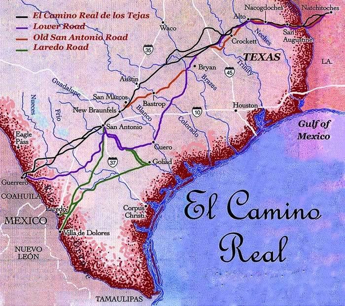
The Old San Antonio Road (sometimes called “El Camino Real” or “King’s Highway”) was a historic roadway located in the U.S. states of Texas and Louisiana. Parts of it were based on traditional Native American trails. Its Texas terminus was about 35 miles (56 km) southeast of Eagle Pass at the Rio Grande in Maverick County, and its northern terminus was at Natchitoches, Louisiana. The road continued from Texas through Monclova to Mexico City. The Old San Antonio Road is considered a part of El Camino Real de los Tejas National Historic Trail.[1]

In 1915, the Daughters of the American Revolution (DAR) received $5000 allocated by the Texas Legislature to mark the route of the Old San Antonio Road. Old San Antonio Road took a traveler from the Texas-Mexico border near Eagle Pass to San Antonio, then past Austin and into East Texas, eventually out of Texas to Natchitoches, Louisiana. Civil Engineer, Van Neiman (V. N.) Zively was hired to map out the route of Old San Antonio Road.[2] The idea to preserve the trail was from Claudia W. Norvell who was a member of DAR. She had seen the work on the Santa Fe Trail and noted that the Old San Antonio Road was much older, and thus must be preserved. DAR raised another $13,000 for the project for a total of $18,000 (about $460,007 today).
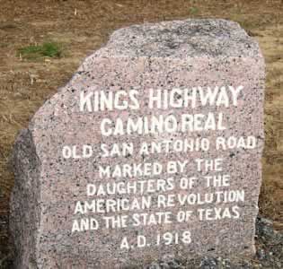
Zively studied diaries, maps, and other documentation to locate the route. This route was 500 miles in length and not a single route. The road started as a Native American trail, then worked on the by the Spanish in 1689. Zively studied the road in the field noting wagon ruts and shapes of the cut road in the forested areas that varied from 10 to 20 feet. The road was a network of trails and paths allowing early Texas travelers to get from the Sabine River to Rio Grande River near Spanish missions and settlements, so travelers could avoid bad weather or route around possible attacks by the native inhabitants. After Texas Independence, there was no longer a great need to travel to the Rio Grande River where most of the goods came into Texas, which now arrived via New Orleans and the coast. Because of this, the route was not used as often, and by 1850, the adjacent landowners were requesting to fence in their land.
Old San Antonio Road is one of the oldest roads in Texas and has countless engineers working on it for almost 200 years now.
Born in 1851, Zively attended the University of Texas and was taught by T.U. Taylor. Zively had moved with his family from Alabama and lived in Austin and Lampasas, serving as the Lampasas County Surveyor for several years. On his grave in Lampasas, a monument depicts him working to survey the road. In 1929 the Texas legislature designated the Zivley version of the Old San Antonio Road one of the historic trails of Texas, but Zively died in 1922 not seeing how his work would be adopted.
For Zively, the task of designating each route had become cumbersome. Zively placed granite monument markers along the road every 5 miles. We know this from field notes and a detailed map of Kings Highway found dating back to 1916. Marking the trail, the markers were transported via the railroad and a reduced rate freight. When possible, Zively tried to put the markers at significant places like county lines and all the markers were placed on the righthand side as one traveled East to West from from Louisiana to Mexico. Eventually, the task was completed at a final cost of $18,544.
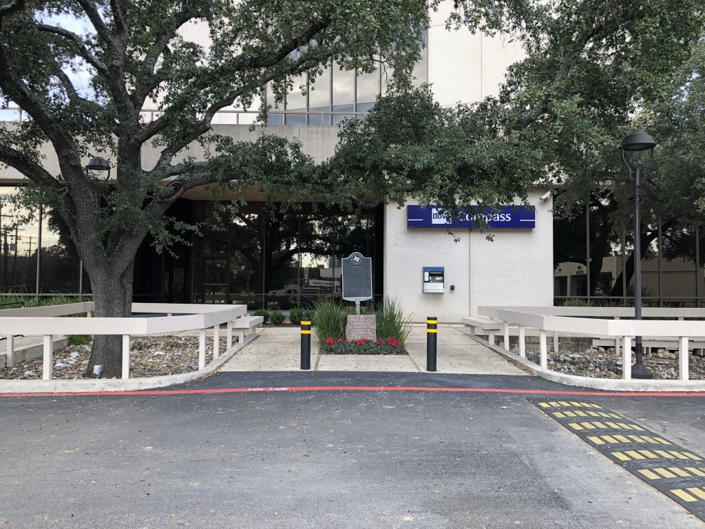
In 1979, Texas Historical Commission placed a Texas Historical Marker on the Route of El Camino Real in Bexar County. This is located on the Southwest corner of Highway 410 and Nacogdoches Street in a parking lot. There are additional historic markers throughout Texas marking the route of this historic road.
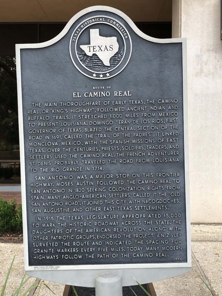
In 1991, Texas commissioned a study to make recommendations for a preservation plan of the road. One of the suggestions was to work towards obtaining National Historic Trail status. The recommendations also included developing education materials and tourist materials to publicize the history of the road. The goal was reached in 2004 when George W. Bush signed a bill to designate the road a National Historic Trail. While most of the original monuments placed by Zively have been relocated, in 1993, ASCE dedicated El Camino Real Eastern Branch as a National ASCE Landmark. [View additional National ASCE Landmarks in Texas]
Today it is difficult to see what Zively saw when mapping the Old San Antonio Road, since it has been 170 years since its last use and the land has changed. Yet some claim you can still see wagon ruts, the cuts of roadway through forest areas, and other indications of the road. Today TexasCounties.net and civil engineer David Herbert are using lidar to get a clearer picture of the routes of the Old San Antonio Road. With any luck, this new technology may offer a way to preserve the trail as well.
To see if you live near a monument and to check out this historic road, we suggest you start here.
[1] Wikipedia; https://en.wikipedia.org/wiki/Old_San_Antonio_Road; accessed 05 Oct 2020.
[2] TSHA; https://www.tshaonline.org/handbook/entries/old-san-antonio-road; accessed 05 Oct 2020.


