A Close-up Look into Trinity Regional Flood Planning
Authors: Stephanie W. Griffin, PE, CFM, F.ASCE and Audrey Giesler Klump, EIT, CFM, Halff
A Close-up Look into Trinity Regional Flood Planning
Introduction
With the submission of regional flood plans across the state earlier this year and the impending delivery of a State Flood Plan to the Texas Legislature in 2024, Stephanie W. Griffin, PE, CFM, F.ASCE, and Audrey Giesler Klump, EIT, CFM, provide an in-depth look into how the Trinity Regional Flood Plan group built, coordinated and delivered the region’s first flood plan.
Background
The Trinity watershed is no stranger to floods resulting in loss of life and property. Floods in May and November 2015 resulted in presidential disaster declarations. The devastating floods from Hurricane Harvey prompted the 86th Texas Legislature to action when they convened and approved Senate Bill 8 (SB 8), directing the creation of the first State Flood Plan. The Texas Water Development Board (TWDB) was appointed to oversee the development of the first State Flood Plan for Texas.
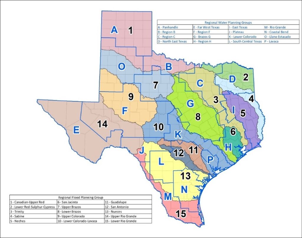
The TWDB modeled the State Flood Plan after the bottom-up approach that has been used in regional water planning for more than 20 years. The TWDB established 15 regional flood planning groups (RFPGs) in accordance with watershed boundaries. Figure 1 shows the regional water planning group boundaries with blue letters and the regional flood planning boundaries with black numbers.
Each RFPG is responsible for preparing a regional flood plan according to the TWDB’s scope of work. These plans are to be compiled to create the State Flood Plan and updated every five years.
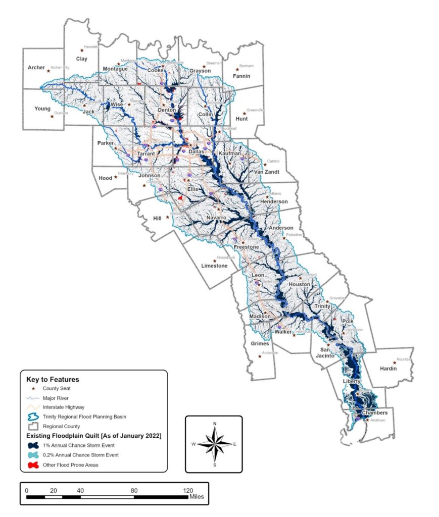
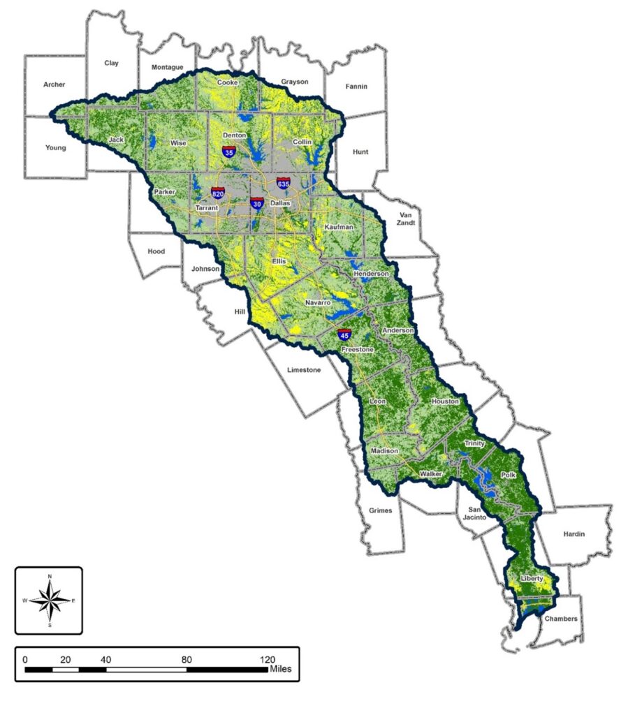
Region 3, also known as the Trinity Regional Flood Planning Group (Trinity RFPG), reaches from Cooke County in the north and follows the I-45 corridor southeast to Chambers County, where the Trinity River discharges into Galveston Bay as shown in Figure 2. Region 3 encompasses all or portions of 38 counties, totaling nearly 18,000 square miles, approximately 15,800 river miles, and impacting more than 7.8 million people.

Logistics
The RFPG’s voting membership consists of volunteers representing 12 specific interest categories. They selected the Trinity River Authority of Texas to serve as their sponsor to perform administrative activities, including contract execution and management, monthly billing, TWDB audits and oversight of the project schedule. The RFPG selected the Halff Team in Spring 2021 as its technical consultant (TC) to develop the region’s first regional flood plan. Other team members included Freese and Nichols, H2O Partners, Cooksey Communications and Dr. Nick Fang.
RFPG meetings are subject to the Texas Open Meetings Act (TOMA) and the Freedom of Information Act (FOIA), which require meetings to be open to the public. Meetings were held in locations throughout the region to generate local interest. Most of the meetings were offered in a hybrid format for two primary purposes:
- Reduce travel for RFPG members who were far from the meeting location
- Provide the public a convenient option to participate in the plan development
Data Collection
A public outreach program, developed by the TC, solicited input from entities with flood responsibilities and the public.
The TC began by designing a data collection tool for the Trinity Region. The tool included questions about floodplain ordinances, future land use plans, known flood-prone areas, current stormwater infrastructure, ongoing and planned stormwater projects and studies, low-water crossing locations and more. Documents and models could be directly uploaded to the tool.
The public was also encouraged to provide local input by responding to questions, marking interactive maps with locations of known flood issues and describing their flooding concerns.
The TC mailed postcards and sent emails with login instructions for the data collection tool. These were sent to at least two individuals within each entity with flood responsibilities. The consultant team called each entity to confirm receipt of the email and/or postcard and to confirm that the entity was able to access the tool. Information promoting the tool was also posted on the RFPG’s website.
By the Chapter
The Trinity Regional Flood Plan features ten chapters, each related to a key element of flood planning. The following section provides a summary of each chapter and any notable or unique findings that resulted from the first flood planning cycle.
Chapter 1: Overview of Region
Variations in population, projected growth, land use, industrial types, income levels, available flood risk maps, models, and flood-prone areas provide unique challenges in the Trinity Region. The Trinity Region has several relatively large cities that have completed local watershed studies with maps, models and flood mitigation alternatives. However, due to a lack of resources, small communities often rely on federal or state agencies to develop and provide flood risk information. Available data is inconsistent throughout the region.
Following the 1942 Dallas-Fort Worth flood, the United States Army Corps of Engineers (USACE) Fort Worth District was established to construct dams for flood control purposes. The Texas Commission on Environmental Quality (TCEQ) identified 1,409 dams in the Trinity Region that are permitted for flood control. Only eight of these are owned, operated and maintained by USACE. Other constructed flood mitigation infrastructure in the region includes levees, stormwater management systems, bridges and culverts.
Chapter 2: Current and Future Flood Risk
The Trinity RFPG was tasked with identifying current and future flood risk areas. The TWDB provided Geographic Information Systems (GIS) files for the RFPGs to use as a starting point, including critical facility locations, flood infrastructure locations, and terrain. Most of the Trinity Region already had flood mapping information available from the National Flood Hazard Layer or from other Federal Emergency Management Agency (FEMA) avenues or TWDB Base Level Engineering studies. For areas without flood risk maps, the TWDB provided data from First American Flood Data Service and Fathom. These datasets were combined to create a flood quilt. The TC further improved the flood quilt with local information provided through the data collection effort. The existing condition floodplain quilt shows flood risk areas for the 1% annual chance storm event (100-year) and the 0.2% annual chance storm event (500-year) as shown in Figure 3.
The TC performed a flood exposure analysis for existing conditions. Approximately 2.32 million people would be affected by a region-wide 100-year flood event. The structure value exposed to this flooding exceeds $636 billion and increases significantly for the 500-year flood. The Trinity RFPG considered social vulnerability and community resilience in its analysis.
Additionally, the consultant team performed a future condition flood risk analysis for the 100-year and 500-year storm events. The RFPG considered a “no action” scenario spanning 30 years of continued development and population growth under current development trends and existing flood regulations. The TC also considered climate variability, sea level change, land subsidence, variable rainfall patterns, reservoir sedimentation and geomorphic changes. The RFPG expressed concerns about defining the future condition of flood risk given the number of variabilities that impact this potential outcome. To address these concerns, the TC analyzed multiple smaller watersheds and determined that the average horizontal distance between the current 100-year and 500-year floodplain boundaries was approximately 40 feet. The RFPG recommended that the future 100-year floodplain range between the current 100-year and current 500-year flood risk and the future 500-year floodplain range between the current 500-year flood risk plus a 40-foot buffer. Figure 4 provides an example of the RFPG’s approved range for future flood risk. The results of the future scenarios include 29% more structures, and 25% more people impacted.


Chapter 3: Floodplain Management and Goals
Floodplain Management Standards
The data collection phase included questions regarding floodplain management standards desired or implemented within the Trinity region. Though the Trinity RFPG supports communities who implement floodplain management standards that meet or exceed the minimum FEMA standards, the RFPG decided to recommend, not require, seven floodplain management standards, which include:
- Participate in the National Flood Insurance Program (NFIP) or adopt equivalent standards
- Regulate development in the FEMA floodplain or other local floodplain designated by local jurisdiction
- Establish higher standards (more stringent than the NFIP) for development or freeboard above the floodplain
- Support drainage corridor preservation
- Utilize land use standards to reduce future flood risk
- Consider compensatory flood storage
Planning Goals
Regional and state flood plan goals are “to protect against loss of life and property.” The Trinity RFPG carefully formulated seven overarching goals with specific and measurable statements. The RFPG established a subcommittee to fine-tune the statements, short-term and long-term measurements to determine the impact of the regional flood plan in future planning cycles.
The RFPG-approved goals include:
- Improve flood warning and public safety
- Improve flood analyses
- Reduce property damage and loss
- Preserve the floodplain
- Improve flood infrastructure
- Expand panel education and outreach
- Expand funding
Each of the recommended actions in the Trinity Flood Plan must meet at least one of these goals. In future cycles of regional flood planning, the RFPG will evaluate the region’s progress in accomplishing these goals, with the option to amend goals if necessary.
Chapters 4 and 5: Potential and Recommended Actions
Data collection included requests for existing watershed studies and resulting flood mitigation projects and activities. The TC reviewed the data provided from entities and categorized the results into one of three categories:
- Flood management evaluations (FMEs): flood analyses or studies
- Flood mitigation projects (FMPs): actual projects with 30% design features
- Flood management strategies (FMSs): “catch-all” for other actions, such as ordinance updates and buyouts
Table 1 shows the number of potentially feasible FMEs, FMPs and FMSs that the Trinity RFPG considered and the number of each recommended in the plan.
Table 1: Potentially Feasible and Recommended Actions
| Category | Potentially Feasible | Recommended | Percent Recommended |
| FME | 521 | 507 | 97% |
| FMP | 73 | 56 | 77% |
| FMS | 145 | 138 | 95% |
| Total | 739 | 701 | 95% |
Including an action in the regional flood plan allows entities with flood responsibilities to pursue funding from the TWDB for those specific actions. Subsequently, the Trinity RFPG wanted to include as many actions in the flood plan as possible. The FMP qualifications are stringent and include information not traditionally developed during watershed studies, including the “No Negative Impact” (NNI) requirement. In many cases, the NNI was the one item lacking for the action to include a potentially feasible project. Without that information, the project was categorized as an FME in need of the NNI determination.
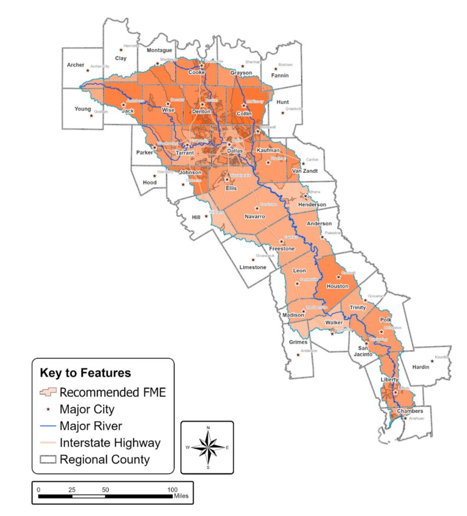
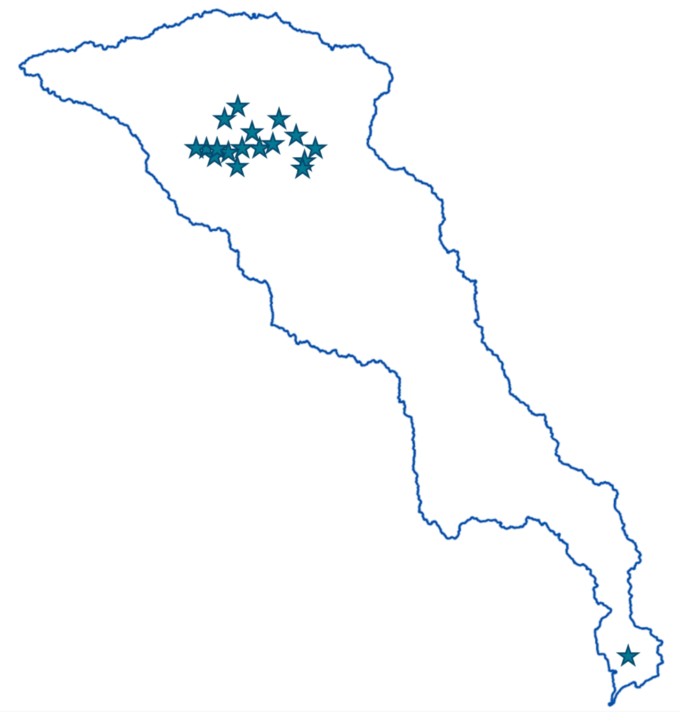
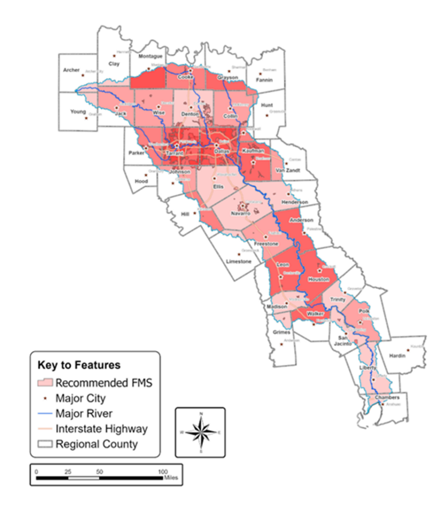
Figures 5, 6 and 7 show the recommended FMEs, FMPs and FMSs throughout the region.
Chapter 6: Potential Impacts
The impacts of the recommended actions are considered in this plan. The recommended actions cannot have negative impacts on others. Even if the recommended FMPs are implemented, residual flood risk remains. For example, if a storm exceeds the design capacity of a project, the project will not prevent flooding but may reduce the flood impacts. The Trinity RFPG considered the opportunity for recommended FMPs to provide water supply benefits. However, none resulted in any significant additional water supply.
Chapter 7: Summary of Flood Response
Multiple entities and agencies have responsibilities for developing, implementing, and maintaining flood response plans. The Trinity Flood Plan identifies typical entities involved in flood preparation and response. Flood response measures and measures to improve resilience are based on responses to the data collection tool.
Chapter 8: Recommended Improvements to the Flood Planning Process
As the Trinity RFPG worked through this first regional flood planning effort, they identified opportunities to improve future cycles of regional flood planning. The Trinity RFPG recommended eight legislative measures and nine regulatory and administrative improvements. The RFPG further identified 17 recommendations to ease the next cycle of regional flood planning.
Chapter 9: Funding
Flood planning provides the Texas Legislature with an estimate of the amount of funding local sponsors may need to implement their recommended FMEs, FMPs, and FMSs. The TC surveyed each of the sponsors of recommended actions to confirm that the action was still desired and to inquire how much of the project cost the sponsor would likely be able to fund.
SB 8 requires that FMEs, FMPs, and FMSs be recommended in regional and state flood plans for the sponsor to be eligible to pursue TWDB funding. When funding becomes available, the sponsor can apply for funding to the TWDB. The Trinity RFPG does not have the authority to implement the recommendations within the plan.
The total cost of the recommended actions in the Trinity Flood Plan comes to $1.6 billion. Based on survey responses, the Trinity RFPG anticipates that local sponsors will need approximately $1.4 billion in funding from outside sources to implement the recommendations.
Chapter 10: Public Outreach
Local participation in representing the flood risk and flood mitigation needs is vital to the Trinity Flood Plan. The TC, with input and direction provided by the Trinity RFPG, developed a robust outreach program that included an award-winning website. The TC developed and continues to maintain a contact list for the entities with flood responsibilities. As of June 2023, the database included more than 900 individuals who received notifications of upcoming meetings and opportunities to engage with the RFPG.
All public meetings adhered to the strict requirements of TOMA. Meeting notifications and materials pertaining to the specific topics to be discussed were provided in advance of each meeting.
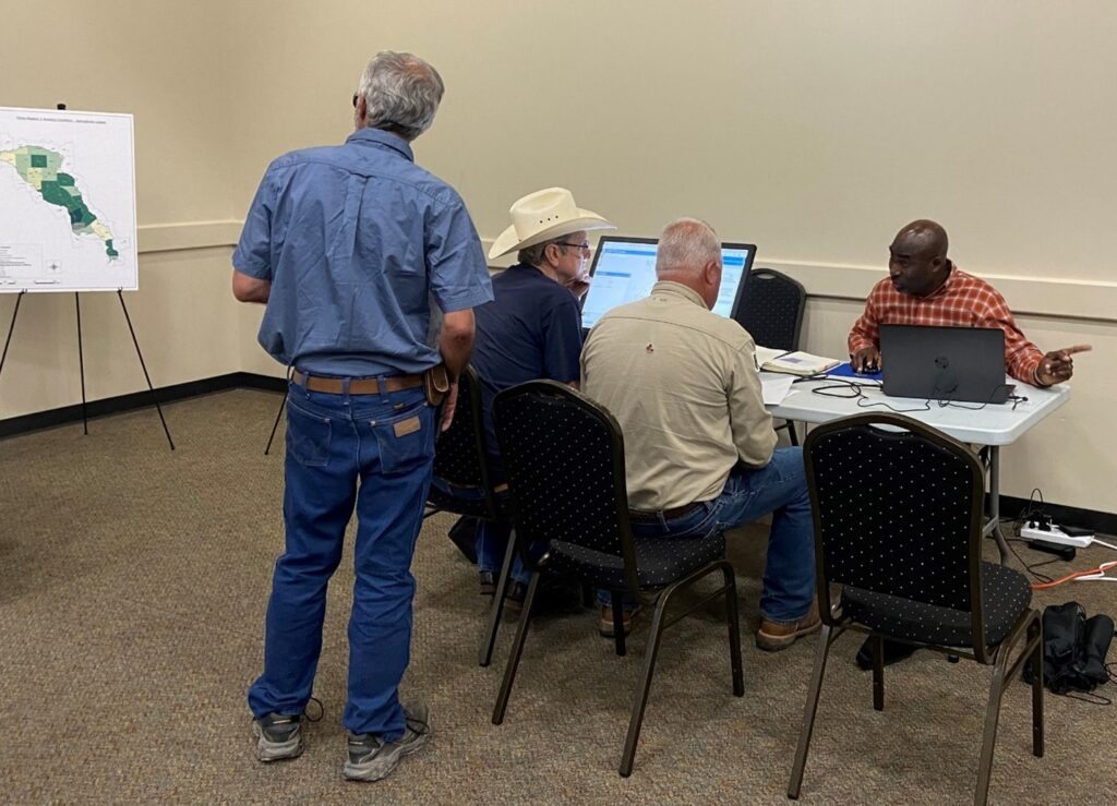
In August and September 2022, the Trinity consultant team and select RFPG members hosted a series of open houses around the region to present and obtain feedback on the draft plan. The open houses were held in the evenings to encourage public participation and included an overview of the draft plan and recommended actions. Various stations were set up to encourage public insight on known flood-prone areas that needed to be incorporated within the plan.
The TC developed postcards, flyers, and other informational tools for the RFPG members to share opportunities for public involvement in the plan development. The TC developed a PowerPoint slide deck for the RFPG members to use when they had the opportunity to speak on the flood planning effort at external events. Additionally, the TC established and maintained a social media account to provide updates on RFPG activities as well as developed press releases and media advisories. Several media outlets conducted interviews with RFPG members and published articles to encourage public participation in the planning process.
Trinity RFPG Challenges and Solutions
Challenge #1:
Initiating a new flood planning approach during a pandemic was the first challenge for the RFPGs. The TWDB posted information on its website and sent emails to registered recipients, but the RFPGs found that local entities were unaware of the flood planning effort. Subsequently, participation was very low to start.
The TC developed a unique website specific to the Trinity Region. The website included an overview of the region, the purpose of flood planning, planning group categories and representatives, meeting information, planning documents, communication options, and the link to the data collection tool when in use. The TC obtained contact information for floodplain administrators, city managers, mayors, emergency management directors, general managers, and others within entities with flood responsibilities to develop a distribution list. The TC maintained the contact list and used it to track which entities had been contacted about the planning effort and when. This list further served as a starting point for the e-blast distribution list that was used to notify interested parties about upcoming Trinity RFPG meetings and activities. The distribution list remains an active document and is continuously updated.
Challenge #2:
The Trinity Region encompasses a large watershed area with a wide variety of flooding concerns. The entities within the Trinity Region stressed the importance of acting as a unit to address regional flooding. Nevertheless, distinctions were needed regarding subregional concerns.
The Trinity RFPG divided the region into three subregions based on similar population and growth patterns. The upper region encompasses the Dallas-Fort Worth (DFW) metroplex and surrounding counties which continue to experience significant population growth. The upper region is experiencing land use changes from rural to urbanized purposes as development extends outward from the Metroplex. The middle subregion includes communities with mid-sized populations and more agricultural lands. The middle subregion is growing at a slower rate compared to the upper region. The potential implications of a fully developed upper basin are concerning to the middle region as they balance their heavy agricultural economy with growing population centers. The lower subregion consists of communities with smaller populations and significant agricultural lands. The lower region also includes industrialized areas, coastal preservation, and coastal meteorological events. While these subregions recognize their individuality, their dedication to working together as a region provides the most well-rounded solution to the Trinity Region’s flooding problems.
Challenge #3:
The Texas Legislature specified in SB 8 that the first cycle of regional flood planning had to be completed by January 10, 2023, giving consultants two years to complete what would typically be done in four years. Data collection efforts occurred at the end of summer – right in the middle of budget planning for most communities. Changing the SB 8 deadline would prove difficult.
Regional flood planning had to be built from scratch and needed to be completed in an expedited fashion.
The Trinity RFPG, along with other regions, saw issues almost immediately, as data collection began right as entities were honing in on their fiscal year budgets. Cities and counties were focused on determining their communities’ financial needs for the upcoming fiscal year.
In response to the Trinity RFPG and others, the TWDB obtained additional funding and time from the State for the RFPGs to prepare amendments. The SB 8 deadline for the final plans did not change, but the amendments provided additional funding and an additional six months for the RFPGs to develop amended plans immediately following the submittal of the final plans. The Trinity RFPG utilized this extra time to solicit additional FMEs, FMPs, and FMSs across the region. The additional six months ultimately allowed the number of projects included in the Trinity Regional Flood Plan to more than triple.
Stephanie W. Griffin, PE, CFM, F.ASCE, a senior project manager at Halff Associates Inc., who has more than 20 years of experience as a stormwater engineer, water resources engineer, and project manager, has been named a Fellow by the ASCE Board of Direction. She holds bachelor’s and master’s degrees in civil engineering from Texas Tech University and Texas A&M University, respectively.
Audrey Giesler Klump, EIT, CFM, is an Engineer-In-Training & CFM at Halff Associates, Inc
Figures(s) courtesy of: Trinity RFPG
